Map design
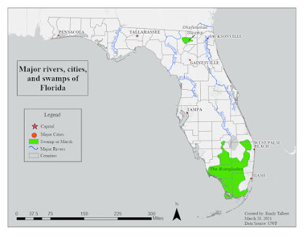
This week in my cartography course we learned about typography and map design. The goal of this module's exercise was to create of map of Florida that exercised our new knowledge about proper map design and develop our personal map making style. The main goal was to properly use and design labels in this map. The map of Florida was to include major rivers, cities, and swamps/marshes.
I used ArcGIS Pro to create this map and complete the exercise. The main tools I used within Pro was labeling, symbology, and annotations. I used the labeling tools to edit the format of my labels. I used symbology to select which features and labels were displayed. I used annotations to design and edit the labels in an easier format.
I chose to customize my map in three ways. 1) I changed my base map to "light grey map" but I removed the "light grey reference" layer that contained pre made labels. 2) I made the point symbol for the capital a star so it stood out from the other major cities, which were a circle. They were the same color to maintain consistency. 3) I used a leaderline for the Okefenokee Swamp because the text would not fit completely in the feature. There was other text around it and I wanted to make it very clear.
I think my personal map making style is pretty simple and straightforward, but I am sure it will develop as I learn more and make more maps.


Comments
Post a Comment